Members of the project team visited the Concord Free Public Library this morning to examine several maps and images that were pulled from the library’s archives by Leslie Wilson’s team of archivists. We are very grateful for their assistance and we enjoyed studying the items they discovered. Check out a few images from our visit below:

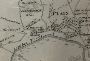
The image above is a portion of an 1875 map of Concord and Westvale. The McGrath Site still belonged to the Barrett family at this point; the Col. James Barrett House is identified in the image as the “P. Barrett Est.” (or, the Prescott Barrett estate). What we found curious was the presence of the “Acushnet Race Course,” which, given its proximity to the Barrett House, must have originally been positioned either on or adjacent to what is now the McGrath Farm Site. Our initial forays into learning more about the Acushnet Race Course haven’t turned up any information, but we’re eager to learn more.

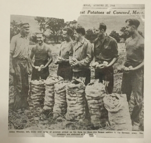
The image above is from an article in a local paper published on Nov. 11, 1989. The article describes residents who recall German P.O.W.’s from nearby P.O.W. camp Fort Devens coming to Concord to work on several local farms. Although the McGrath Farm isn’t mentioned by name, several residents have mentioned in oral testimony that they recall visiting with German soldiers working at the McGrath site.

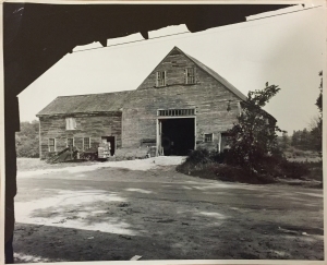
This final image was something of a curiosity. When we first examined it, we had trouble determining what it was depicting. After studying it for a time, we realized that shows the large barn the once stood to the west of the Barrett House. Archaeological and historical research places the barn’s dismantling in the 1970s. What is also interesting about this image is the perspective from which it was taken. The photographer was clearly standing inside a structure or shelter of some kind, and based on the distance between the photographer and the Barrett barn, the image seems to have been taken from the McGrath property. While we first were excited because we thought the image may have been taken from inside the bunkhouse we’ve been seeking archaeologically, it soon became apparent that this was a different structure. Based on its location, it seems to have been a shelter that once stood near the road on the McGrath property; visual inspection of this area reveals a three-sided stone foundation. Our best guess is that this was a farm stand that was used in the 20th century prior to the construction of the current farmstand.
As we continue our research, hopefully we’ll have more information to share!
